
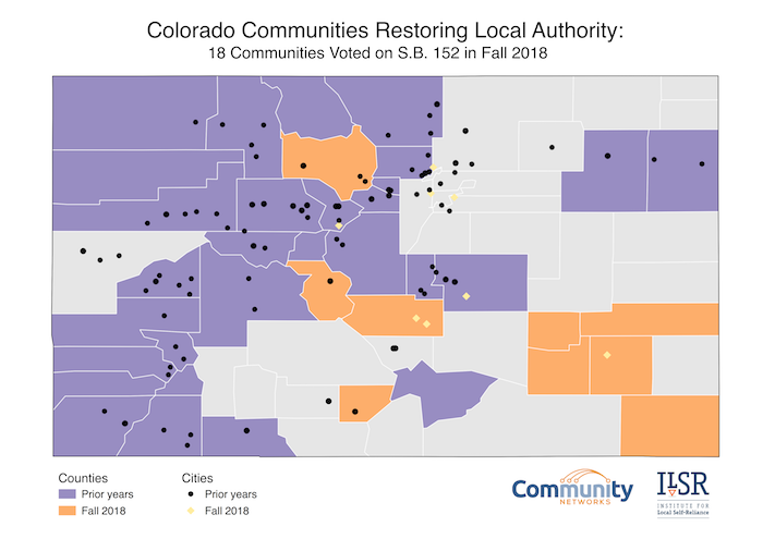
Colorado Map: Local Authority Expanding Across the State

A total of 40 counties and 102 municipalities have now chosen local telecommunications authority by passing ballot measures to opt out of restrictive state law. Last November, 18 counties, cities, and towns voted to join the expanding list of communities opting out of SB 152, which revoked local telecommunications authority in 2005. We decided to update our map to get a new visualization of what the situation now looks like in Colorado.
Take a gander:
Moving Across the State
The map, updated by Intern and Mapping Maven Hannah Bonestroo from an earlier version created by former Research Associate and Visualization Virtuoso Hannah Trostle, shows how the decision to opt out is sweeping from region to region. Earlier referendums centered in the Mountain and into the Western Slope and San Luis Valley communities. During this past election cycle, most of the counties bringing the issue before voters were in the Plains region.
In past years, mountain towns, often resort communities, were looking for better connectivity when big ISPs considered deployment too challenging and expensive in their geographies. Now, it appears that the rural and less populated Plains communities are seeing value in reclaiming local authority.
With fewer population centers in the Plains region, farms and ranges fill much of this section of the state. Large, corporate ISPs don’t consider this type of landscape profitable due to the lack of population density, however, farmers and rangers require high-speed Internet access for various reasons. Crop and livestock monitoring and realtime reporting are only a few of the ways 21st century agricultural professionals use broadband.
Colorado’s Free Communities
In Colorado, there are 271 active incorporated municipalities, 187 unincorporated Census Designated Places (CDPs) and other small population centers that are outside of CDPs or municipalities. To date, the 102 municipalities that have elected to opt out of SB 152 have all been incorporated municipalities, or approximately 38 percent.