Institute for Local Self-Reliance, Next Century Cities, and Allies Offer Insight to FCC on Broadband Data Collection
When local communities apply for funding to improve local Internet infrastructure, grants and loans are often predicated on the need to deploy to unserved and underserved premises. Whether it's federal, state, or local sources, Federal Communications Commission (FCC) data determining whether or not a region has access to broadband is often the data that funding entities rely on. In recent years, it’s become apparent that FCC data grossly understates the lack of accessibility to broadband. Finally in August 2019, the FCC called for comments as they reconsider how to collect fixed broadband data. The Institute for Local Self-Reliance teamed up with Next Century Cities and several other organizations with whom we often collaborate, submitted both Comments and Reply Comments.
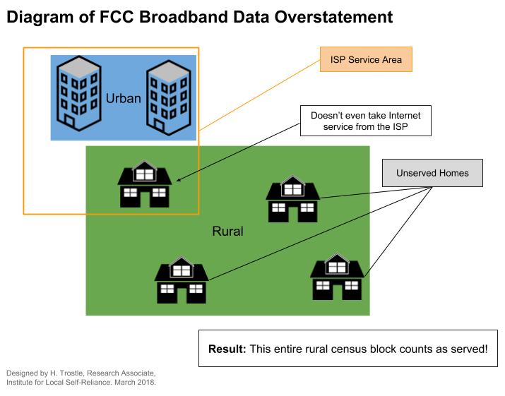
Fixing the Bad Data
We’ve covered this before, and the Commission has now decided to make changes. Traditionally, FCC data on broadband Internet access has been collected from Internet service providers (ISPs) that self-report on the areas they serve via Form 477. If a company has the ability to serve one premise in a census block they report to the Commission that they serve the entire block. Reality, however, often does not reflect such a high level of connectivity in one area.
When FCC data incorrectly determines that locations have the ability to subscribe to one or more Internet access companies, those areas lose eligibility for grants and loans for Internet network infrastructure. Sadly, these places are often caught in a strange purgatory between faulty FCC data and reality in which they can’t obtain funding to build out high-quality Internet access, and yet large Internet access companies don’t consider their areas a good investment due to low population densities.